.:Main Menu:.
| Forest and Carbon Monitoring |
|
Baseline Monitoring for Carbon Stock Change in Merang Peat Swamp Forest Introduction Merang Peat Swamp Forest (MPSF) is the last peat swamp forest in South Sumatra province. MPSF is also located in a large peat dome and therefore stores huge amount of carbon. Illegal logging and forest fires are the current threats. REDD mechanism could break the deforestation trend and thus increasing carbon sequestration. REDD mechanism requires internationally approved carbon accounting system. The higher the precision level of carbon measurement, the more convenient it would be for carbon trading negotiation. IPCC has published general guidelines for carbon stock and emission measurement. One can use the default value provided in the guidelines as references to calculate carbon stock. This method doesn’t require big effort and to be considered as Tier 1. Tier 2 will employ data compiled from national level. Data sets for this method are available from many different carbon study conducted in Indonesia. It will be suitable for Merang REDD Pilot Project to measure carbon stock and emission in MPSF using Tier 3 method with higher precision.
Landscape assessment Biomass and soil are the biggest carbon pools in the peat swamp forest. However due to variation in forest use and threats, different carbon stock will occur at different vegetation types across the landscape. It is important to have landscape-scale land cover assessment using remote sensing technique. The technique also allows land cover change assessment using time series remotely sensed imageries. Historical as well as actual satellite imageries are available for such assessment. It is very useful for carbon stock change analysis at landscape level. At this point, it is actually possible to calculate merchantable volume of carbon using Tier 1 or Tier 2.
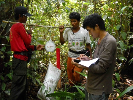
Plot measurement Land cover map derived from satellite imageries, should be used for area stratification. Additionally, peat depth information should give more information on stratification for carbon stock. Plots for biomass inventory will be distributed at each stratum. Carbon inventory will measure carbon stock from above and below ground biomass as well as dead organic matters. It is possible to use allometric equation to estimate total carbon stored in a tree based on DBH measured in the field. Some equations have been developed to accommodate carbon measurement in tropical countries (Kettering et al, 2001; Chave et al, 2005; Brown, 1997). Analysis on the inventory data results in amount of carbon stock per hectare of each stratum. This will be used to upscale carbon measurement in landscape level.
Tree-based biomass quantification It will be much more convenient to estimate tree biomass based on local allometric equation developed from similar forest types. MRPP Project is conducting a study on allometric equation in peat swamp forest to get higher level of precision in carbon calculation. The nearest forest type which has been studied for alometric equation is Jambi lowland secondary forest (Kettering et al, 2001). Most of the study site located in mineral soil, hence should be differ to those in peat land. We are developing local allometric equation based on harvesting method. The calculation of total carbon content of each stratum will integrate both inventory results and local alometric equation. |

|