.:Main Menu:.
| Fire Management |
|
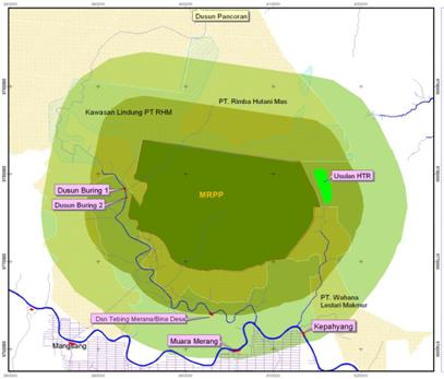
Deforestation rate of Indonesian tropical rainforest is increasing in an alarming rate. During period of 2003 – 2006, about 1.17 million Ha of forest have been deforested annually (Ministry of Forestry, 2008). Moreover, degraded forest and land have increased risk of fire occurrence, which emit huge amount of carbon to the atmosphere and contributed to global warming. Therefore, protecting the existing tropical forest will be an important issue to reduce the deforestation rate as well as removing CO2 to the forests. Reducing Emissions from Deforestation and Degradation (REDD) is a solution for financing mechanism to protect remaining tropical forest from deforestation and degradation. The Merang Peat Swamp Forest (MPSF) is located in Lalan Production Forest (Hutan Produksi Lalan) in Bayung Lencir Sub District of Musi Banyuasin District, South Sumatra Province. The MPSF occupies and area of about 180,000 ha and is part of larger peat swamp area linked to Sembilang National Park in its eastern extent, Muaro Jambi peat swamp forest to its north (adjacent to Jambi Province) and Berbak national park on its northwest boundary. The MPSF is located between Medak and Kepayang rivers. The MPSF is considered to be the last remaining large contiguous peat swamp forests in South Sumatra Province.
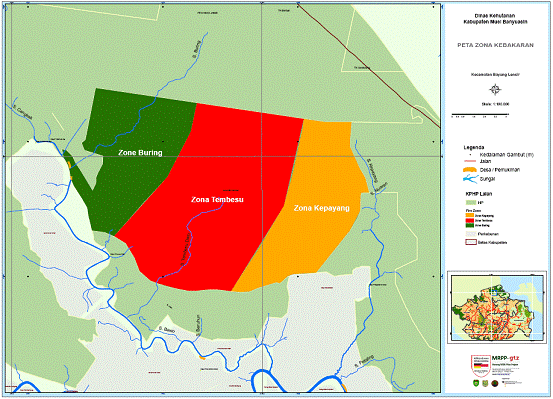
The most significant threats to the MPSF ecosystem include illegal logging and recurring peat fires. The Merang Peat Swamp Forest (MPSF) has a long history of fires. Locals have been reporting fires since the 1960s with a trend revealing that fires occurring in 1982, 1987, 1997 were much more severe (Lubis, et al, 2004). This increase in severity can in part be attributed to logging practices which contributed to a change in the ecological condition of the peat dome from a mesic or wet ecosystem to a more xeric or dry fire prone system. Opening up of forest canopy resulted in more sunlight dry out forest floors. Illegal loggers exacerbated the situation by digging small canals for extracting logs out from the forest, which effectively drained water out the dome during the dry season. Other sources of ignition have been identified as being from cigarette butts and cooking fires used by loggers. Objectives The objective of this Fire Management Plan is to ensure that stakeholders in the area, including Forest Management Units (FMUs) and Community Forest Rangers (CFRs) are adequately trained and equipped to reduce the impact of fire in the forest carbon project area and surrounding forests. Fire Zones The forest carbon project area is located in the centre of a peat dome which covers an area of approximately 24,000 ha (Figure 2). The area has become partly degraded and deforested and also very susceptible to fire during El Nino events. This is in part due to logging by a previous timber company as well as illegal logging by local community members. For fire management purposes, the area is divided into 3 zones, namely Buring, Tembesu and Kepayang. Each zone is divided according to its primary river access (Buring River, Tembesu River and Kepayang River).
Figure 2. Fire zones of project area. The area is devided into 3 zones, Buring, Tembesu and Kepayang. Each zone is divided according to its main river access (Buring River, Tembesu River and Kepayang River). Buring Zone The Buring zone is located in the western part of the project area (Figure 2). The zone shares most of its boundary with PT Rimba Hutani Mas (timber plantation) to the west and north. The Buring river provides the major access route into the zone. The Buring is considered a small river, with a relatively low water level during dry season. Small boats are therefore an important means of transportation with respect to fire management operations. For the purposes of effective fire management in this zone, water is usually available along the river and its channels through out the year. Even small channels with limited depth contain water during the dry season. However, a technique known as channel blocking will increase the water table providing a strategic and reliable water source during the dry season. It restores the hydrological system and reduces emission from peat decomposition. The majority of the Buring zone is covered with logged-over peat swamp forest that remains in relatively good condition. However, at present there is significant illegal logging activity in the zone. Illegal logging will most likely lead to an increase in the probability of fire occurrence resulting from deliberate ignition or carelessness by illegal loggers. Illegal logging aside, Buring zone is still considered to be a green zone meaning that it has a relatively low risk of fire occurrence. Tembesu Zone The Tembesu zone is located in the centre of the project area (Figure 2). It is the most fire prone zone, due to previous and current extensive Illegal logging. As a result of illegal logging activities most of the area is degraded and deforested, particularly near the channels which provide easy transportation of illegally harvested timber out of the zone. The channels were primarily developed for accessibility and the transportation of legal timber. The primary channel in the Tembusu zone is a man made extension of the Tembesu River which was originally only about 1 km in length. Including the channel, the river is now more than 20 km in length . This increase in water flow from the peat dome has led to the gradual reduction in the water table in the vicinity of the dome resulting in a dryer more fire-prone ecosystem. As is the case in the Buring zone, water is usually available along the river and its channels through out the year. Even small channels with limited depth contain water during the dry season. However, a technique known as channel blocking will increase the water table providing a strategic and reliable water source for fire management operations during the dry season. Increasing water table will also avoid emissions from peat decomposition. Kepayang Zone Kepayang zone is located on the eastern side of project area (Figure 2). Approximately?? Ha or % of this zone is deforested and the zone as a whole exhibits a moderate risk of fire occurrence. The main access into the zone is via the Kepayang River, which is a tributary to Lalan River, the largest river in the area. Illegal logging is an activity that continues to take place in the Kepayang zone and surrounding area. As is the case in both the Buring and Tembusu zones, water is usually available along the river and its channels through out the year. Even small channels with limited depth contain water during the dry season. However, a technique known as channel blocking will increase the water table providing a strategic and reliable water source for fire management operations during the dry season. Sources of Ignition The majority of fire ignition sources in the project area are anthropogenic (Solichin, 2006; . The motivation behind the man-made ignitions is mostly for the procurement of timber. Specifically: - Clearing shrubs using fire for the purposes of improving access to timber and maintaining the wooden railway used to transport timber. - Carelessness by illegal loggers in using fire for cooking - Carelessness of timber sawmills in using fire to dispose off residue (sawdust). - The traditional use of fire in hunting activities by local community members adjacent to the project area. Community Fire Crews Given the fact that most ignition sources are anthropogenic or man-made, it is therefore very important to adopt a Community-Based Fire Management (CBFiM) approach to achieve effective management. CBFiM is an approach to fire management in which local communities are actively engaged in the development and in some instances implementation of fire management strategies designed to prevent, control or utilize fires in ways that will improve their livelihood, health and security (Johnson, 2010).
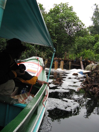
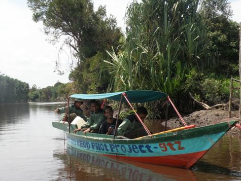
Fire Prevention Fire Patrol Fire patrols are used within the project area. A typical fire patrol is conducted by a CFR member with instruction from the forest manager or MRPP Technical Advisor (Figure 7). The frequency and intensity of Fire patrols are dependent on current FM Readiness Levels (see 4.5). For example, during Readiness Level 3, a patrol should consist of 3 to 4 CFR members with necessary hand tools and back pack pumps. During readiness level 2 and 1, the fire patrol should consist of at least 7 to10 CFR members equipped with hand tools, backpack pumps and a fire pump (regular fire pump or floto pump).
Figure 7. A fire patrol and boat using one of the canals in the project area during FM Readiness Level. The objectives of fire patrol are to: 1. Assess fire-related situations within the project area and adjacent areas. Patrols usually have a focus on fire prone areas. 2. Conduct awareness campaigns and extension efforts to communities working in fire prone areas with an overall objective of avoiding or minimizing uncontrolled fires. 3. Achieve early detection of fires enabling effective early suppression of fires before they become large and uncontrollable.
|
|