.:Main Menu:.

| Fire |
|
Fires have been reported by the locals since 1960s. However, fires in 1982, 1987, 1997 were muc more severe (Lubis, et al, 2004). This is because the logging had taken place and changed the ecological condition of wet peat dome ecosystem into drier one. Moreover, illegal loggers worsened the situation by digging small canals through the forest, which could drain out the dome during dry season. Carelessness from either cigarette butt or cooking fires from loggers were believed to be the other sources of ignition. Hotspot data shows that fires hit severely MPDF in 1997, mostly in the degraded area near the river. The domes still remain intact. However, new trends of logging activities started in 2003 inside the area where the proposed project will operate, as hotspot were detected in the area (circled area). This is an indication that human activities started in that area, mostly illegal logging. The risk of ignition map, shows this area as a high risk level area. 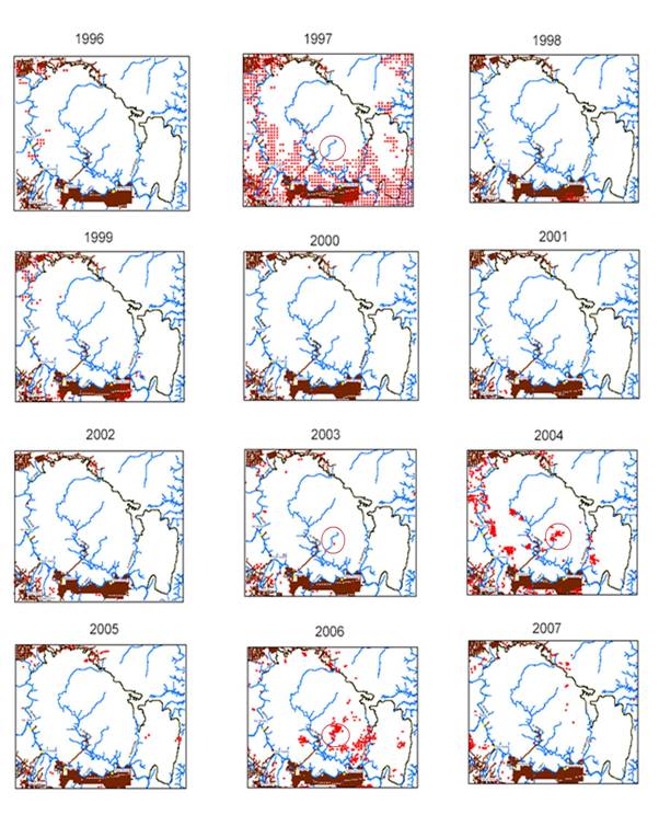
In 2004 and 2006, fires hit inner side of the peat dome, following illegal loggers (red circle). The area was very-degraded and dominated by ferns and poles. This area will likely burn again during the next El-Nino event. In 2009, many fires have been detected during site preparation by oil-palm contractors. Most of area in the riverbank with shallow peat soils are allocated for palm oil plantation.
|

|