The Directorate for Forest Resources Inventory and Monitoring (IPSDH) of the Ministry of Environment and Forestry in collaboration with FORCLIME has published an article in the Indonesian Journal of Geography (IJG) titled “Current achievements to reducing deforestation in Kalimantan” (IJG Vol. 50 No 2 December 2018). The paper analyses gross deforestation rates and emissions from deforestation in the five provinces of the island of Kalimantan which occurred in the time after 2012, i.e. 2013 until 2015, and puts them in relation to the average annual deforestation and emission rates of each province in the historic reference period 1990-2012, which is the baseline defined in the Indonesian Forest Reference Emission Level (FREL).
The results show a mixed picture: The overall linear trends of gross deforestation and emission rates in Kalimantan are pointing downwards (see Fig. 1) but with considerable annual fluctuations particularly in the recent past. However, the developments in reducing emissions from deforestation vary greatly between the five Kalimantan provinces, as it is to be expected due to their different biogeophysical and economic settings, logging histories and initial and remaining forest resources. While South, Central and East Kalimantan have a linear downward trend in the long term and thus seem to be on a good way in terms of reducing deforestation, West and North Kalimantan show a rather bad performance in terms of reducing deforestation. Nevertheless, the actual emissions from deforestation accumulated since 1990 are barely below the Business-As-Usual (BAU) scenario (see Fig. 2). This shows that the overall efforts across all five Kalimantan provinces were up to now not sufficient to achieve significant emission reductions compared to the projected BAU scenario.
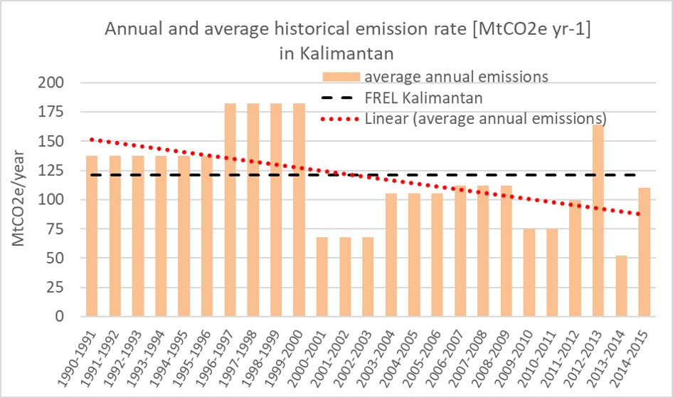
Fig. 1: Annual average emission rates for the island of Kalimantan (red bars) with FREL (black dashed line) and the linear trend of the annual emissions (red dotted line).
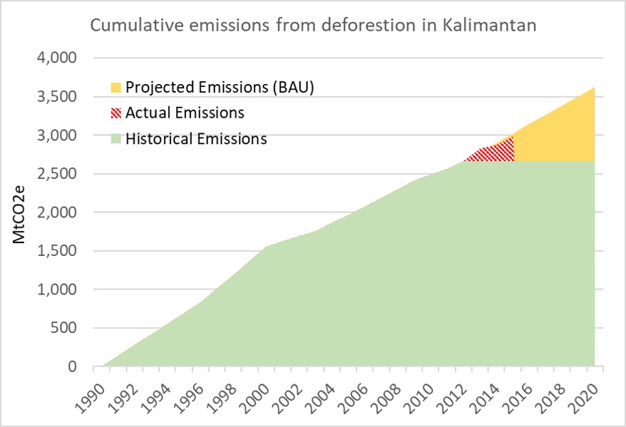
Fig. 2: Cumulative emissions from deforestation in Kalimantan. Historical emissions from the historical reference period (1990-2012) are displayed in green, the BAU for the projection period (2013-2020) in yellow and the actual emissions in 2013, 2014 and 2015 in red
For more information, please contact:
Stephanie Wegscheider, Development Advisor GIS/Remote Sensing